Wildlife Monitoring · IoT
Arabian Oryx Hema Wildlife Monitoring System
“Conservation intelligence for Oman's wild frontier”
Portfolio / Arabian Oryx Hema Wildlife Monitoring System
Client
Location
Discipline
Scope
A connected monitoring platform for the Arabian Oryx Hema in Oman, uniting IoT sensing, mapping and mobile access so conservation teams can track wildlife, read the land and act in real time across roughly 50 kilometres of remote terrain.
Across roughly 50 kilometres of open Omani wilderness, the work of protecting the Arabian oryx happens far from any control room. It happens in the heat, in the dust, in the long patrols between waypoints. Our task was to give that work a digital backbone: a monitoring system that turns scattered field signals into a single, legible picture, and puts it in the hands of the people who need it most.
Overview
The Arabian Oryx Hema is a protected conservation area where the survival of a once-vanished species is measured in daily vigilance. We were asked to design and build an end-to-end wildlife monitoring system spanning sensor infrastructure in the field, a command dashboard for administrators and specialists, and a mobile layer for teams on the ground.
The brief was not simply to collect data. It was to make that data trustworthy, immediate and useful in a setting where connectivity is uncertain, distances are vast, and a delayed decision carries real consequences for animals and habitat alike.
The Challenge
Conservation environments are unforgiving to software. The system had to operate against intermittent connectivity, harsh conditions and a wide territory that no single observer can cover. Information arrives from many directions at once: animal movement, environmental readings, the location and status of field activity. Left raw, that flood obscures more than it reveals.
There was also a human dimension. Field teams, administrators and monitoring specialists each approach the same reality from different angles, with different urgencies. A specialist studying movement patterns over weeks needs something quite different from a ranger who needs to know, right now, where to go and what to expect. The interface had to serve all three without forcing any of them to think like an engineer.
What We Designed and Built
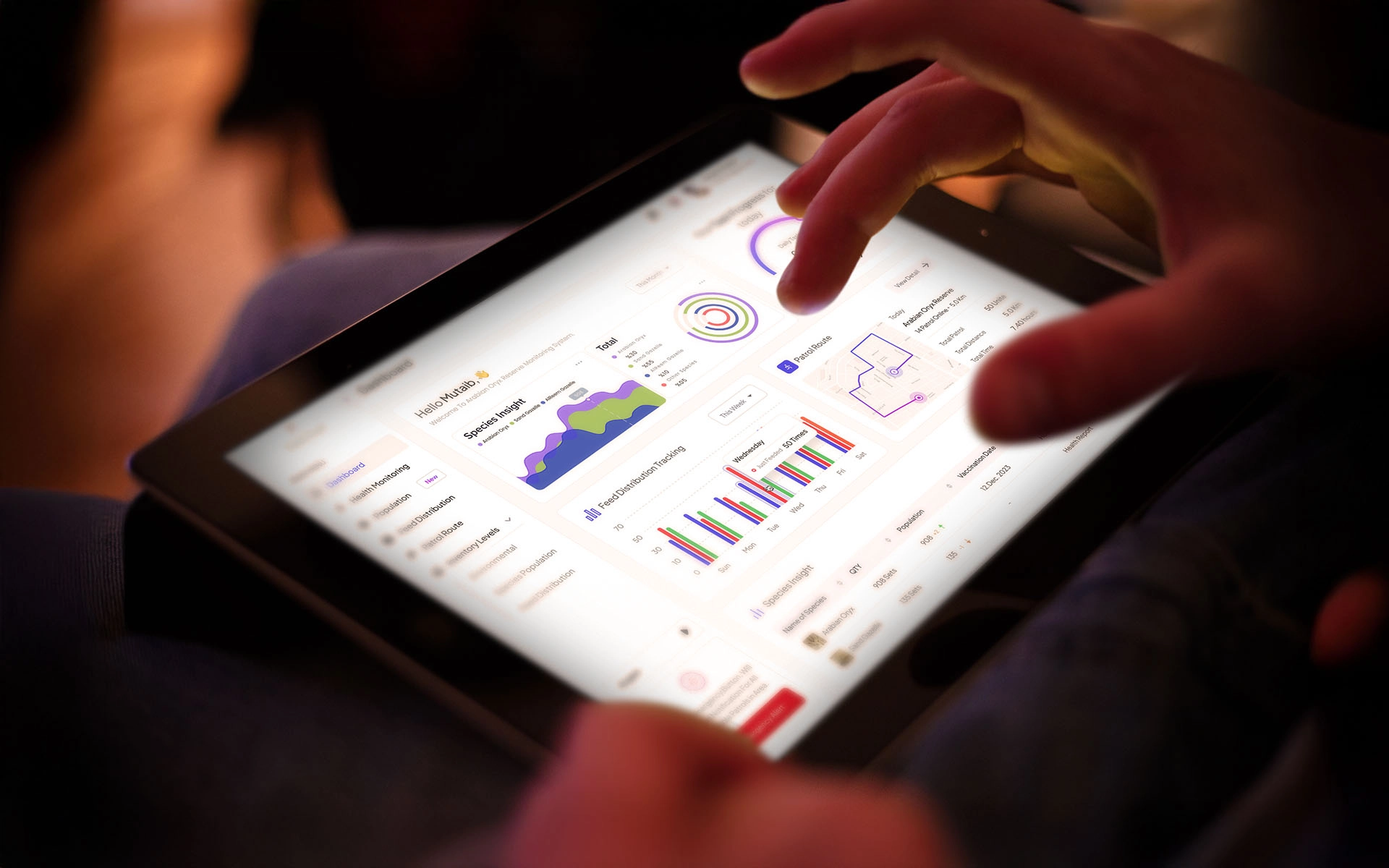
We delivered a unified platform connecting IoT infrastructure in the field to monitoring dashboards and a companion mobile application. Sensor and tracking signals flow into a central system, where they are organised, visualised and surfaced as clear, actionable indicators rather than untreated numbers.
The core of the experience is the map. Animal positions, environmental conditions and field activity are layered onto a single spatial view, so that location, context and status are read together rather than reconstructed in someone's head. Around it sit the working tools of daily conservation:
- Live status indicators that summarise the health of the system and the situation in the field at a glance.
- Alerts that draw attention to what has changed or what needs a response, filtering signal from noise.
- Monitoring workflows that guide teams through observation and reporting in a consistent, repeatable way.
- Data visualisation that renders movement and environmental trends as patterns a non-specialist can interpret.
Our Approach
We began with the field, not the screen. By grounding the design in the real rhythms of patrol and observation, we kept the interface practical and reliable rather than ornamental. Every view earns its place by answering a question someone actually asks during a working day.
Complexity was handled by hiding it. The technical depth sits beneath a calm, restrained surface: simple status language, generous visual hierarchy, and a deliberate reduction of each screen to the decisions it supports. We designed for legibility under pressure and at speed, including the moment when a tired ranger glances at a phone in bright sun. The mobile layer mirrors the dashboard's logic so that moving between command and field feels continuous, not like learning a second tool.
The Experience
In use, the system behaves less like a database and more like a colleague who already understands the terrain. An administrator opens the dashboard and immediately reads the state of the reserve. A specialist follows movement across days and seasons, drawing meaning from the visualised data. A field team carries the same intelligence outward, receiving alerts and confirming activity from wherever the work takes them.
The result is a shared operating picture: one version of the truth, expressed clearly enough that everyone, regardless of role, can act on it with confidence.
Outcome and Impact
The platform sits precisely at the intersection of technology and environmental responsibility. It supports faster, better-informed decisions in remote natural settings, reduces the friction of coordinating teams across a large area, and gives conservation specialists a dependable lens onto animal movement and habitat conditions.
More than a monitoring tool, it is infrastructure for stewardship. By making the invisible legible and the urgent obvious, the system helps the people protecting the Arabian oryx spend less effort wrestling with information and more on the work that matters: keeping a species, and the land that sustains it, alive.
What we brought
01
02
03
04
05
Have a project like this?
One in-house team carried Arabian Oryx Hema Wildlife Monitoring System from strategy to launch. Tell us what you're building and we'll send back a clear plan.
Next project
Superlaundry — Rebranding & Customer Portal